

Utility Mapping for Accurate Underground Detection
Utility Mapping for Safe and Reliable Site Development
Utility mapping is an essential part of modern construction and infrastructure planning. Before any excavation or groundwork begins, knowing exactly where underground utilities are located ensures safety, reduces risks, and saves both time and money. Whether a project involves roadworks, commercial development, or residential construction, utility mapping provides the accurate data needed to avoid costly disruptions and ensure smooth project execution.
Understanding Why Utility Mapping Matters
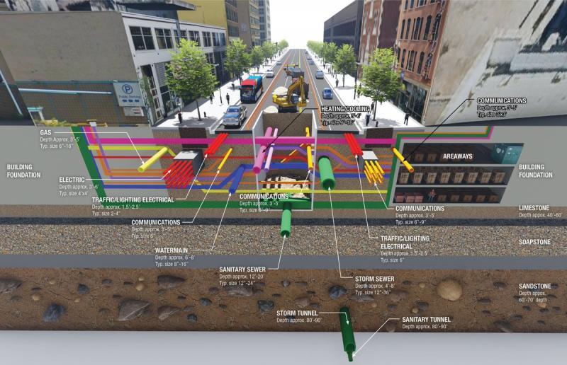
Utility mapping involves identifying, locating, and documenting underground utilities such as gas lines, water pipes, electricity cables, telecommunications systems, drainage networks, and more. Without clear and updated utility information, construction projects are exposed to serious risks. Damaging an underground service can cause delays, expensive repairs, safety hazards, and even legal consequences.
By investing in detailed utility mapping before starting a project, developers and contractors gain a complete picture of the subsurface environment. This knowledge allows engineers and planners to design foundations, routes, and layouts that avoid existing utilities, reducing uncertainty and potential complications during construction.
Advanced Tools for Accurate Detection
The accuracy of utility mapping has improved dramatically in recent years thanks to advanced technology. Tools such as Ground Penetrating Radar (GPR), electromagnetic locators, GPS instruments, and 3D scanning systems enable surveyors to detect utilities with precision. These non-invasive methods allow teams to gather data safely without digging or disturbing the site.
Modern mapping methods provide real-time data, clear visual representations, and comprehensive reports that help project teams make informed decisions. This high level of accuracy ensures that projects stay compliant with safety standards and industry regulations.
Supporting Construction Safety and Efficiency
One of the most important benefits of utility mapping is improved safety. By knowing exactly where underground utilities lie, workers can perform their duties with confidence. Preventing accidental strikes protects not only the workforce but also the surrounding community. In addition, accurate mapping speeds up construction workflows by reducing unexpected interruptions and redesigns.
Utility mapping also supports effective planning. Contractors can determine the most efficient excavation paths, access routes, and service connections. This leads to streamlined operations and reduced project costs.
Comprehensive Mapping for All Project Types
Whether working on a small residential extension or a major commercial project, utility mapping provides essential information for all types of sites. It is particularly crucial in urban areas where underground utilities are dense and complex. Even older properties can have unidentified or undocumented utilities, making mapping a necessary precaution.
Ensuring Compliance with Industry Standards
Construction and engineering projects must follow strict regulations regarding safety, environmental protection, and utility management. Utility mapping helps ensure compliance by providing documented proof of underground service locations. This protects project owners and contractors from legal issues and supports a responsible approach to infrastructure development.
Delivering Accurate Reports for Project Planning
Once the mapping is completed, surveyors generate detailed utility reports. These documents include maps, diagrams, digital models, and descriptions of all detected utilities. They are essential for architects, engineers, and contractors during the planning and execution stages.
Integrated Support Through Utility Surveys
In the final phase of project preparation, many teams rely on utility surveys to complement their mapping data. These surveys provide an additional level of verification that ensures all underground utilities are accurately identified.
Why Utility Surveys Are Important for Project Success
Professional utility surveys combine mapping technology with expert analysis. Survey specialists interpret data, conduct further tests when needed, and confirm the presence and depth of underground services. Their role is essential in ensuring that the mapped data is complete and reliable before excavation begins.
Enhancing Safety and Reducing Risk with Utility Surveys
With utility surveys, contractors receive even more detailed information, reducing the chances of unexpected findings during groundworks. This step improves safety, strengthens planning decisions, and supports efficient project delivery. When combined with utility mapping, surveys offer full-spectrum protection against errors and delays.
Final Thought
Using utility mapping is a critical step for safe, efficient, and well-planned construction projects. It provides accurate, reliable data that protects workers, prevents costly damage, and ensures regulatory compliance. When supported by expert utility surveys, project teams gain complete underground insight, allowing them to carry out excavation and development work with confidence. Investing in these services is one of the most effective ways to guarantee successful project outcomes from start to finish.